Magnetic Declination - FS9, FSX, P3d and MSFS-2020
/Flight simulator whether it be FS9 or FSX, is quite long in the tooth as far as software programs go. These programs was released several years ago and during this time span there have been many improvements in computer technology and in real world flying procedures. When released, FS9 and FSX contained the latest navigational data, including the correct declination, VOR, and ILS radio frequencies; however, these are now out of date with real world counterparts.
Magnetic Declination
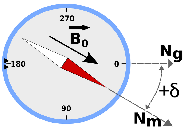
Magnetic declination has a very important influence on air navigation, beginning with the use of the standard compass and sectional flight chart. Similarly, radio navigation aids on the ground, such as VORs use magnetic variation to ensure reliable and accurate in-plane navigation. The direction of the runway also relies heavily on magnetic variation and runway directions often require updating to ensure that ILS systems operate as designed.
Simply explained, magnetic declination is the difference between true north and magnetic north and the value changes each year. Flight Simulator is referring to a value that was accurate when the software was developed but has changed considerably in the ten years plus since the program was released.
I realized a problem existed when I noticed that the direction of the runway did not align correctly with the latest navigational database installed into ProSim737 (Navigraph). The CDU continually issued advisory warnings informing me that the runway direction and database were not identical. Although it's possible to ignore the warning advisory, it becomes tiresome to continually reset the CDU whilst in the more demanding phase of approach and landing.
Updating Magnetic Variation
Screen grab of program interface
Updating this data is easy thanks to Herve Sors. Herve has developed a free stand alone program that easily and quickly updates the magnetic variation in either FS9 or FSX whilst also providing the opportunity to rectify out of date and changed runway directions. The information can be updated globally or by country region, and if necessary you can revert back to the old data.
Without going into unnecessary detail, the program decompresses, corrects, and compiles the necessary information within the .BGL files, located in the scenery folder of flight simulator; it's in this folder that the various navaids are recorded.
Do I need To Update ?
The ability of simulator to accurately simulate navigation is only as good as the navigational database installed. Think of the database as a street directory or telephone book - do you want to search the directory for out-of-date information? The update is a very simple process and takes but a few minutes and it's strongly recommended.
By updating virtual pilots will benefit at the very least from:
All VOR and NDB data will be up-to-date, allowing chart usage to easier with current charts.
Correct calibration of magnetic declination of navaids that provide an azimuth information (VOR/VORDME/NDB) that will be greatly improved matching the "as real as it gets" experience while navigating (tracking navaid radials will be as it is indicated on charts).
ILS data (for those that are corrected, Europe only at this time) will be correct.
To download the required software (FSX World NavAids 4.32 & MagVar Data) and investigate Herve's various other programs, navigate directly to his website at AeroSors NavAids.
The software also updates the database for Prepar3D and MSFS-2020.
More recent article: Magnetic Declination and Navigation Database Update (January 2017).