Updating Magnetic Declination in MSFS-2020

Sometimes, the aircraft during an approach does not correctly align with the runway heading published on the approach chart. This can lead to a RW/APP CRS Error to be displayed on the FMA.

Before exploring scenery, navigational database and add-on inconsistencies, the problem may be that the magnetic declination in flight simulator is not correct for the runway or scenery being used.

The magnetic declination forms part of the database table that relates to any scenery (and airport runway) used in flight simulator.

I have written about magnetic declination in two earlier articles, however, these articles related to FS9 and FSX and not MSFS-2020.

Magnetic Declination

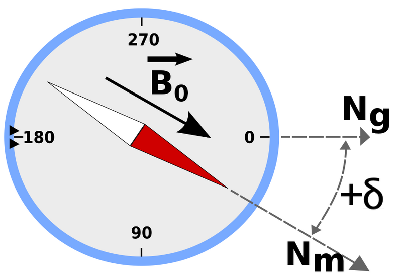
Simply explained, magnetic north is the direction that the north end of a compass needle points, which corresponds to the direction of the Earth's magnetic field. True north is the direction along a meridian towards the geographic North Pole. The magnetic declination (also called magnetic variation) is the angle measured between true north and magnetic north.  This distance changes annually and is one of the reasons that a topographic map has a declination table printed in the margin. Without a declination table, the map would soon become inaccurate.  To calculate the magnetic declination the map user, depending upon their position, would add or subtract the declination from the bearing to obtain an accurate bearing to plot a course.

Flight Simulator

The magnetic declination used by flight simulator is stored in a .bgl file named magdec.bgl. This file is usually located in the simulator’s scenery database.  The file is accurate at the time of development, but if not updated regularly will be incorrect for today’s date.

You would expect magnetic declination errors with flight simulator platforms such as FS9, FSX and earlier versions of P3d; after all, they were released several years ago, but deviation errors are also seen in MSFS-2020.  The reason for this is that Microsoft did not compile a new magnetic declination table when the scenery was developed; rather, they used the existing table from FSX.  The exception being for some of Asobo’s airports which probably do have up-to-date declination.  

Considering that MSFS-2020 is automatically updated, it would have been a relatively easy task to also update the magnetic declination (perhaps in the future).

Updating Magnetic Declination

Updating the declination for MSFS-2020 involves replacing the magdec.bgl file with an updated file.

This file can be downloaded free of charge from Herve Sor’s website (the .bgl file is regularly rewritten to reflect declination changes).  Be sure to read the accompanying Read Me file for further information.

Locating the .bgl file (MSFS-2020)

The magdec.bgl file is located in the following directory: 

  • C:\Users\LOGINNAME\AppData\Local\Packages\Microsoft.FlightSimulator_8wekyb3d8bbwe\ LocalCache\Packages\Official\OneStore\FS-base\Scenery\Base\Scenery

Note that if you have done a custom install of MSFS-2020 to a different drive, then the folder structure should represent the location you have installed the software.

If using Steam, the folder structure is:

  • C:\Steam\Steamapps\Common\MicrosoftFlightSimulator\Official\OneStore\fs-base\Scenery\Base\Scenery\

Installing the .bgl file

Find and open the scenery folder.  Prior to changing anything, always make a backup of the existing magdec.bgl file.  Be sure to remove the .bgl file extension.  I would suggest renaming the file to magdec_backup_original.  This enables you, if necessary, to easily roll back the file (after changing the file name back to the original name).  The backup file can either remain in the folder or be removed to another location for safe keeping.  Next, copy and paste the new magdec.bgl file to the folder.  When you open flight simulator the magnetic declination table will be rebuilt during the start-up process. This may take a few minutes.

Important Point:

  • After downloading the zip file from Herve’s website, open and read the Read Me file which provides additional information.

Other Simulator Platforms

To update the magnetic declination for other simulation platforms, ensure you download the correct updated magdec.bgl file for the simulator being used.  The installation route is usually the Scenery/Base/Scenery folder.

Magnetic declination is important. The declination information for the approach chart and the simulator must be identical

Do I Need To Update ?

The flight simulator can only reproduce accurate navigation based on the quality of the installed database. If you are using Navigraph data and your simulator’s declination is not correct, a corresponding error will occur between Navigraph and the scenery in the simulator.

If you use an approach chart, the magnetic declination record between the chart and the simulator must be identical; otherwise, the approach course will be inaccurate (landing left or right of runway).  Likewise, if you are using Lateral and Vertical Navigation (LNAV and VNAV) and have the incorrect declination, the aircraft will not fly the correct course during an automated approach (for example an RNAV approach).

The update is a very simple process and takes but a few minutes and it is strongly recommended.

Final Call

Magnetic declination is a critical factor to consider, before investigating other potential causes for navigational discrepancies. To ensure accurate navigation ensure the magdec.bgl file is up-to-date.

Glossary

  • FMA - Flight Mode Annunciator.

Installing the Navigraph Database to ProSim-AR (ProSim737)

No matter which avionics suite is used, the navigational database and approach charts will need to be kept up-to-date.  Navigraph (the company) have for many years been the mainstay in supplying accurate navigational data to the flight simulator community.

The navigation database and monthly updates can be downloaded from the Navigraph website, and can either be manually installed to Flight Simulator, or alternatively you can use Navigraph’s FMS Data Manager software to install the files.

This short article will benefit only those using the ProSim-AR (ProSim-737) avionics suite Version 3.  ProSim-AR Version 2 uses a different file structure and navigation path.

Database Files and Installation

Navigraph is the navigation database used by ProSim737.   The database is purchased separately to ProSim-AR and navigation updates (AIRAC cycles) are released monthly.

The correct navigational database for ProSim737 to download from the Navigraph website is: ProSim737 2.24b1 (and above).

When installed the database consists of three files:

  • cycle.json;

  • cycle_info.txt; and,

  • nd.bb3.

Cycle-info.txt is a text file that indicates which navigation database has been installed.  This is the file you need to open if you are unsure of which AIRAC cycle has been installed.  The other two files relate directly to the database.

Once the database is installed or updated, the ProSim737 main module (.exe file) must be run, and the database rebuilt.

To rebuild the database, open the ProSim main module, select Config/Database and Build Database.  The process to rebuild the database will take around 5 minutes.  When completed, the installed database AIRAC cycle number will be displayed.

Database Fails to Update

If the database does not update, there is a possibility that either the downloaded file is corrupt, or more than likely the database has been installed to the incorrect folder structure within ProSim-AR.

In this case, download the required files from Navigraph, uncompress the files to your computer desktop (or anywhere else) and copy the three database files to:

C:/Program Data/Prosim-AR/Navdata.

FMS Database Manager Mapping page.  This is where you select the folder structure to upload the AIRAC cycle to

FMS Data Manager

Navigraph have an installer (FMS Data Manager) which is a standalone program that is free to use.  The Data Manager is quite a powerful program and it’s worth the effort examining what this software can do.

When setup correctly, the installer will download, uncompress, and install the Navigraph files to the correct folder structure with ProSim.  The installer also will create a backup of the existing database (if selected).

Navigraph FMS Data Manager main front page.  This is the page where you select Update to update the navigational database with the latest AIRAC cycle

To ensure that the database is installed to the correct folder on your computer, the Data Manager must be configured correctly.  This can be done a number of ways, however, the easiest and most straightforward way is to setup the folder structure manually.

  • Open the FMS Data Manager and select Addon Mappings.

  • Select the black coloured folder adjacent to the purple coloured box named Manual.

  • Select the correct folder in your computer (C:/Program Data) and save the configuration.

To update the database, navigate back to the front page of the manager and select the check box adjacent to ProSim737 2.24b1 and select update.

ProSim-AR (ProSim737) main menu showing the Config page open with the Build Database page overlaid

Important Points:

  • Whenever you install or update the Navigraph database, rebuild the database and check the AIRAC cycle.

Final Call

Maintaining the navigation database is important if you are to get the most from Flight Simulator.  Navigraph AIRAC cycles are released monthly, and it stands to reason that the FMS Data Manager should be used to streamline the installation process.  Problems, when they do occur, usually relate to the FMS Data Manager trying to install files to the incorrect folder structure.

Navigraph Charts Cloud and Charts Desktop - Review

The traditional leather-bound binder that contains hundreds of Jeppesen charts.  This particular binder belonged to Gene Mac Farland, a Captain who flew for 30 years with Continental Airlines

One aspect of simulation which is identical to the real thing is the use of charts.  Whether a professional real-world pilot approaching Heathrow International or a virtual pilot, the correct approach chart will need to be consulted, interpreted correctly, and followed if a safe landing is to be assured.

Not so long ago, Jeppesen Charts provided the mainstay for all professional navigation charts and these thin paper charts were carried in a brown leather binder.  Pilots carried a number of binders with them to allow access to the appropriate chart where necessary.  It was the responsibility of the pilot to ensure that the contents were up-to-date and reflected the latest chart; a tedious task.

Later years have witnessed the introduction of computers and several companies, including Jeppesen, have provide electronic charts that can be viewed using laptops, smart phones and apple i-pads.  The days of  lugging binders is now over, and a binder such the one depicted in the above photograph have become, for the most part, keepsakes and door stops.

Collecting Charts

Virtual pilots have a tendency to ‘collect’ charts from innumerable locations.  The collection can become quite large, and often it is difficult to collate the charts in such a way that it is easy to find the wanted chart, let alone know whether the chart is the most accurate up-to-date version.  

Navigraph

Serious simulator enthusiasts have probably heard of the European-based company Navigraph.  For several years the company has been responsible for the production and distribution of AIRAC cycles that are used to update the Flight Management System (FMS) to maintain the accuracy of the navigation database.

AIRAC Cycles

AIRAC is an acronym for Aeronautical Information Regulation And Control.  An AIRAC cycle contains the current aviation regulations, procedures, and charts for airport, runway, airspace, Instrument Approach Procedures (IAP), Standard Terminal Arrival Routes (STAR), and Standard Instrument Departures (SID).  The AIRAC cycle updates the database used by the aircraft's FMC/CDU.

Without this up-to-date data it is not possible to program the FMC/CDU with any degree of accuracy. 

Navigraph provide a subscription service to AIRAC cycles which are updated several times a year (usually there are thirteen cycles per year)

Charts Database

Navigraph, in addition to supplying regular updated AIRAC cycles, has implemented three additional products:  airport charts, video tutorials and en-route charts.  These products are available via an annual subscription from a data cloud database and/or desktop program.


Area of coverage of Navigraph charts (image courtesy of Navigraph).  This link provides an up-to-date coverage area for Navigraph charts


Airport charts include up-to-date charts for approximately 13,000 airports worldwide. Chart information includes at a minimum: runway data, instrument approach procedures, standard terminal arrival routes and standard instrument departures.  To date, there are approximately 40,000 charts and the number is regularly being expanded with quarterly updates.

Furthermore, several dozen video tutorials instructing in the correct interpretation and use of approach charts are available in addition to dozens of en-route charts which include upper and lower airways.  

The information depicted on the charts originates from suppliers of real-world aviation charts (Navtech) and depicts the latest data, in a format that has been designed by human factor research to be user friendly.

Unlike other companies that have attempted to provide charts for virtual pilots (for example, sim charts), Navigraph charts have been vector scanned in high resolution providing a dataset that can be easily enlarged as required, read, and if required printed in high definition.  Additionally, the information is in colour.  

Ease of Access - Key Feature

In a nutshell, Navigraph has allowed a virtual pilot access to information that otherwise would require considerable collating, revision, and pose difficulties concerning easy access when required. The datasets can be immediately assessed on demand either from a data cloud (charts cloud) or via a desktop program (charts desktop).  

Granted there are many on-line resources to find, read and print approach charts - some better than others.  However, the Navigraph search functionality allows the right chart to be found, quickly and easily, at the appropriate time.  In my opinion, this promotes Navigraph over others programs and on-line resources.

Screen capture of charts cloud showing list of available charts for Hobart, Tasmania, Australia.  The chart can be viewed full screen and can be enlarged as required.  Note this screen capture is of a very reduced quality

Charts Cloud

The cloud provides an easy to use on-line interface, with an effective search functionality that can be accessed using different platforms, including portable devices such as i-pads and smart phones.  To allow speedier future access, charts can be placed in a favourites list or listed in a paper clip (a separate folder) that is linked to your account.  The charts cloud does not allow printing or permanent downloading of a chart and charts are only available when on-line.  Access to the data sets ceases after the annual subscription has expired.

The speed at which charts cloud database can be accessed relates to the Internet connection being used; however, for the most part the server Navigraph uses provides consistent access that should be suitable for most users, with the exception of those that use dial-up.

Navigraph Charts 4 desktop opening screen

Charts Desktop

The charts desktop is a program supplied by Navigraph (free of charge), which resides on your computer and allows charts to be downloaded for access when off-line.  This has the obvious benefit of faster access times if the Internet connection is less than optimal.

The program has the capability to list charts as favourites for easy and fast access, in addition to having a highly responsive search engine.  Unlike the charts cloud, the charts desktop allows access to any chart that has been downloaded after the annual subscription has expired; however, after the subscription has expired the charts cannot be updated.  Another benefit in using the program is that charts can be printed.

Updates

Navigraph regularly updates the database with additional charts and changes to pre-exisiting charts.  The program advises you of an update when you mouse over the chart name.  The program will then allow you to maintain the existing chart or download and replace the chart with the newer version.   Updates are usually half a dozen times a year

Is it a Worthwhile Investment ?

Whether Navigraph chart data is of benefit to you will depend upon how many different airports you fly from and to, how often you fly, and how much money you are prepared to shell out for the convenience and ease of accessed chart information.  Certainly, it is far easier to maintain a collection of charts electronically than store several binders of paper!

A subscription (using the charts cloud or desktop program) is currently 47.92 Euro excluding VAT.  This price allows unlimited access to all charts, and includes the ability to view all instructional videos, which have been professionally produced and run each for approximately 8 minutes duration.  Short of a subscription, individual charts and videos can be purchased separately for a once off fee.  In contrast to purchasing the Jeppesen electronic charts from Jeppesen or an ongoing seller, this fee is reasonable.

Short Review

I elected to not write an in-depth review of Navigraph and their products as the Navigraph interface and their products are constantly being upgraded.  A review may soon be out-of-date!  This review has dealt primarily with the airport charts and has not examined in details the en-route charts or training videos that come packaged with a charts cloud subscription.

Navigraph’s website is very comprehensive and includes several images of their charts that depict the high quality of their product, along with examples of the various programs and how they operate. 

Whilst the charts are not 100% identical to Jeppesen real-world counterparts (various information has been merged and interpolated), the detailed datasets, consistent high quality, and ease of searching and accessibility, make the administrative aspect of virtual flying more enjoyable.

Disclosure

The content in this post is not meant to directly promote or endorse Navigraph.  To trial this software, I purchased a subscription to the charts cloud and charts desktop.  To date, I have been very pleased with the quality of the Navigraph charts and will probably continue to supplement my real-world paper charts with information from this source.

UPDATE: There have been massive changes and improvements to Navigraph since this article was published. A more up-to-date review will be written at some stage. Navigate to the Navigraph website.